==========================
Mid Strip
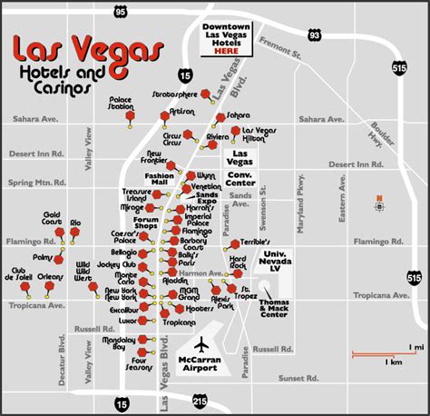
The Las Vegas mid-strip refers to the area south of Sands Ave all the way to Planet Hollywood just before Harmon Ave. Below are hotels located on mid Vegas Strip.
- To be transformed into Hard Rock Hotel & Casino and Guitar Hotel Las Vegas in 2027.
South Strip
The Las Vegas south-strip starts at Planet Hollywood resort and runs south to Mandalay Bay. Below are hotels located on south Vegas Strip.
- Future site of Oakland A's stadium starting in 2028.
Walking the Vegas Strip
Taking a Walk along the Strip is a Vegas thing to do. However, before you embark on your sightseeing walking tour, it helps to have a rough idea of how long it will take you to walk from one mega resort to another.
How long is the Vegas Strip?
The Las Vegas Strip stretches approximately 4.2 miles (6.8 km) in length.
Where is The Sphere and how can I get there?
The MSG Sphere Las Vegas Address:
255 Sands Ave, Las Vegas, NV 89169
Walking to The Sphere
Walking to The Sphere is easy. Head to the Venetian Las Vegas. From there, the venue can be accessed via the Venetian Pedestrian Bridge connected to The Venetian Resort. Visitors can enter the property on foot via the Plaza Entry on the east side of the building via Sands Ave. or Westchester Drive.
Taking the Uber/Lyft (ride sharing) to The Sphere
Rideshare pick up and drop off for Sphere is located at the corner of Sands Ave and Koval Lane. (Pickup Zone is within the Wynn Parking garage)
Riding the Las Vegas Monorail to The Sphere
The nearest Monorail Station to The Sphere is Flamingo/Caesars Palace Station. It's a 4-minute walk away. You can also take the Monorail to Harrah's & The LINQ Monorail Station Las Vegas and walk to The Venetian Pedestrian Bridge and follow the directions to the Sphere.
Taking a Bus to The Sphere
The following buses will get you within walking distance of The Sphere:
- Route 119 – Simmons / Koval Southbound
- Route 203 – Lamb Southbound / Desert Inn & Spring Mtn (Westbound)
- CX – Centennial Express Southbound
- Route 202 – Flamingo Eastbound
- Route 108 – Paradise Southbound
Las Vegas Neighborhoods
Considered the cultural center of Las Vegas, Downtown Las Vegas is made up of seven neighborhoods and features a variety of cultural and historic attractions including galleries, museums, public art sites, shops, restaurants, promenades, and many other points of interest. Old Las Vegas (Downtown) is where you will find:
- Fremont Street Experience
- Downtown Las Vegas Events Center
- Arts District
- Fremont East District
Las Vegas Place and Time
Flight times to Las Vegas
- 5 hours from New York,
- 3 hours from Chicago,
- 1 hour from Los Angeles
Drive times in Las Vegas
- Drive time from Harry Reid International Airport to the Las Vegas Strip is 15 minutes.
- Drive time from Los Angeles to the Las Vegas Strip is 4 hours.
More driving distances:
…
Vintage Vegas Strip
Taken: July 25, 1967 – An aerial of the Las Vegas Strip looking north. On the left is:
- Caesars Palace
- a Texaco
- Budget Rental Car
- Mobil
- Castaways
- and a Denny's
On the right is:
- the Flamingo
- Orange Julius
- Pyramids Motel
- Motel Sand Dunes
- Travelodge
- Four Fountains Restaurant
- and the Sands.
Taken: December 11, 1969 – An aerial of the Las Vegas Strip looking southwest. The Riviera, Stardust, Silver Slipper, and Frontier are the major properties that are visible. The Stardust marquee was 188-feet tall and was the tallest freestanding sign in the world.
Taken: February 25, 1975 – An aerial of the Las Vegas Strip looking north. The Stardust is in the foreground with the Sahara tower in the background.
Fremont Street looking west from 2nd Street circa 1947.
Note: This article has more than 1000 words.
